1-800-833-7958 | Sales@geotechenv.com | Find a Location | Español | 中文 |
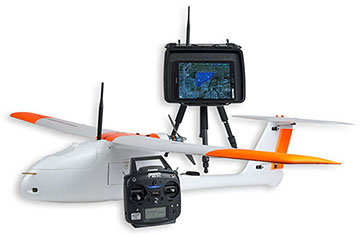
GeoSwift Mapper UAS
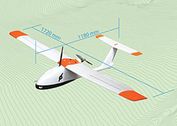
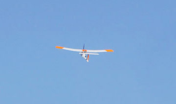
Fixed-Wing Drone
The GeoSwift Mapper UAS was designed as an advanced fully autonomous, yet simple to operate, survey and mapping unmanned aircraft system. The mission planning software is intuitive allowing operators to get up and flying quickly. Take-off is performed through a simple hand launch, and the landing algorithm features a robust and precise autonomous landing.
The GeoSwift Mapper UAS also features an interchangeable camera payload bay providing flexibility to suite your business's needs. Select from one or multiple cameras to produce professional outputs that include:
- Orthomosaic
- DSM (Digital Surface Model)
- Topographic Map
- 3D Mesh With Texture
- NDVI (Normalized Difference Vegetation Index)
- Point Cloud
- Thermal/IR
Aircraft Specifications |
||
| Platform Type Flight Time Area Covered Wing Span Operating Temperature Gross Takeoff Weight Maximum Airspeed Maximum Operational Winds Best Mapping Speed Stall Speed Maximum Rate of Climb Operational Ceiling Payload Operating Temperature Flight Management System |
Fixed Wing 1 hour 600 acres (900 with battery upgrade) 67.5" -5 to 100°F 6 lbs. 44 mph (20 m/s) 25 mph (11 m/s) 30 mph (13 m/s) 11 m/s 4.6 m/s 14,000' MSL RGB or Multispectral -5 to 100°F SwiftCore™ |
|
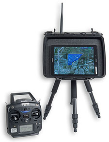
Ground Control Station Specifications |
||
| Flight Management System Operating System Run Time Communication Frequency |
SwiftStation™, SwiftPilot™, and SwiftTab™ Android Tablet, 9.7" Display 4+ Hours 900mhz |
The GeoSwift Mapper UAS includes everything required for conducting mapping missions.
- Aircraft
- Battery
- Ground Station with Tripod
- Tablet Computer
- Field Toolbox
- Carry Case
- Control Handset
- Flight Training
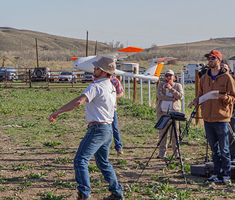
Available Flight Training
Select from one or multiple camera and accessory options that suit your mapping needs.
- Sony a6300 with Optional PPK/RTK (centimeter accuracy)
APS-C 24 MP Sensor
World's Fastest AF (Auto Focus) - MicaSense RedEdge Multispectral Camera
5 Spectral Bands including near – IR - FLIR Vue Pro
Thermal Imaging
Geotech Environmental Equipment, Inc.
2650 East 40th Avenue
Denver, CO 80205

A Geotech Company
Shop our Products Online
© 2024 Geotech Environmental Equipment, Inc. All rights reserved.


| About | Customer Service | Events | Stay Connected | |||
|---|---|---|---|---|---|---|
| Geotech Manuals | Contact Us | Annual Field Days | ||||
| Vendor Manuals | Locations | Tradeshows | Newsletter Sign-Up | |||
| Company History | Warranty & Returns | Photo Competition | ||||
| Mission, Vision & Values | Credit & Terms | |||||
| Community | ||||||
| Press Releases | ||||||
| Careers |